Pine Log WMA is a wildlife management area between White, GA and Canton, GA open to biking, hunting, and equestrian use. I had heard good things so decided to check it out. The place is really remote and has an almost primordial feel too it with barren landscapes and craggy trees where one could imagine a vulture perched upon.
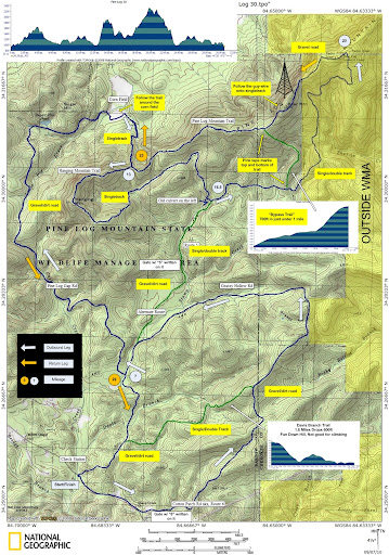
I started out going counter-clockwise following this map

I spent about 90% of my ride time on fire roads, which was disappointing. I managed to find all the awful uphill trails where you could only hope to hike your bike. I'm not exactly sure if I even know which route I took. After about a 90 minutes I wound up back at the parking lot so I at least had some bearings. I think I climbed/walked Davis Trail then circled back on Grassy Hollow Rd. I imagine Davis Trail is much fun going the other way! If I had taken a right somewhere I would've gotten on Route 5 but I never saw a gate with a 5 on it. I remember passing 2 cement bridges crossing a creek on the way back.
Once back at the start, I decided to go clockwise and try to make it to the tower. I saw 2 or 3 towers off in the distance so I wasn't sure which one I was heading to. This was quite a hike on more punishing fire road with long repeated uphills. The sun was really beating down and I think it hit 90 degrees.
I took the first creek crossing to the left and more fire road/forest service road. I was supposed to be looking for a cornfield on the left, according to the map, but the only corn fields I saw were on my right. I wound up crossing a creek which provided much needed cold water to my head and feet. (Note, had bad hot foot today with the Save Our Soles Nose Art socks. Shoe straps may also have been too loose.) Apparently I had gone too far and decided to turn around after another 1/2 mile or so of fire road. I checked out the corn field which was supposed to have a singletrack offshoot and to my surprise I found it, at least what I assume is the singletrack offshoot. Knowing my luck today it could've been some other trail. I was happy to be on singletrack finally after 2.5 hours! It quickly turned in to more punishing uphill fire road. Dammit! Enough of that already. If I had been fresher, I would've kept going but decided to turn around because I knew I had a long way back. Arrived back at the parking lot at the 4 hour mark, completely exhausted.
Overall, I enjoyed Pine Log though found it frustrating not knowing my way around. I still managed to get in some good miles although a lot of time was spent hiking. It is a strangely beautiful area and I'm looking forward to getting back and making it to the radio tower.
I started out going counter-clockwise following this map
I spent about 90% of my ride time on fire roads, which was disappointing. I managed to find all the awful uphill trails where you could only hope to hike your bike. I'm not exactly sure if I even know which route I took. After about a 90 minutes I wound up back at the parking lot so I at least had some bearings. I think I climbed/walked Davis Trail then circled back on Grassy Hollow Rd. I imagine Davis Trail is much fun going the other way! If I had taken a right somewhere I would've gotten on Route 5 but I never saw a gate with a 5 on it. I remember passing 2 cement bridges crossing a creek on the way back.
Once back at the start, I decided to go clockwise and try to make it to the tower. I saw 2 or 3 towers off in the distance so I wasn't sure which one I was heading to. This was quite a hike on more punishing fire road with long repeated uphills. The sun was really beating down and I think it hit 90 degrees.
I took the first creek crossing to the left and more fire road/forest service road. I was supposed to be looking for a cornfield on the left, according to the map, but the only corn fields I saw were on my right. I wound up crossing a creek which provided much needed cold water to my head and feet. (Note, had bad hot foot today with the Save Our Soles Nose Art socks. Shoe straps may also have been too loose.) Apparently I had gone too far and decided to turn around after another 1/2 mile or so of fire road. I checked out the corn field which was supposed to have a singletrack offshoot and to my surprise I found it, at least what I assume is the singletrack offshoot. Knowing my luck today it could've been some other trail. I was happy to be on singletrack finally after 2.5 hours! It quickly turned in to more punishing uphill fire road. Dammit! Enough of that already. If I had been fresher, I would've kept going but decided to turn around because I knew I had a long way back. Arrived back at the parking lot at the 4 hour mark, completely exhausted.
Overall, I enjoyed Pine Log though found it frustrating not knowing my way around. I still managed to get in some good miles although a lot of time was spent hiking. It is a strangely beautiful area and I'm looking forward to getting back and making it to the radio tower.